A recent trip to Ecuador raised my awareness of the vast number of active volcanoes on our planet. They are able to immensely affect our climate. The photo is of Mount Tungurahua, Ecuador, erupting in July 2007 and was taken from the city of Patate, between Baños and Ambato, in the center of Ecuador, near the equator. Clearly, this is not a great place to sleep comfortably.
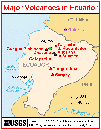
Tungurahua, (Quichua tunguri (throat), rahua (fire): “Throat of Fire” is an active stratovolcano located in the Cordillera Central of Ecuador. The volcano gives name to the province of Tungurahua. Volcanic activity restarted in 1999 and is ongoing as of 2007 with a major eruption on August 16 2006. Mt. Tungurahua (5,023 m) is located in the Cordillera Central of the Andes of central Ecuador, 140 km (87 miles) south of the capital Quito. Nearby notable mountains are the Chimborazo (6,267 m) and El Altar (5,319 m). It rises above the small thermal springs town Baños (1,800 m) which is located at its foot 5 km to the north. Other nearby towns are Ambato (30 km to the northwest) and Riobamba (30 km to the southwest). Tungurahua is part of the Sangay National Park. At an altitude of 5,023 m Tungurahua reaches just over the snow line (about 4,900 m). Tungurahua’s top is snow covered and did feature a small summit glacier which melted away after the increase of volcanic activity in 1999.
Today’s volcanic edifice (Tungurahua III) is constructed inside its predecessor’s (Tungurahua II) caldera which collapsed about 3000 years ago. The original edifice (Tungurahua I) collapsed at the end of the late Pleistocene.
Tungurahua’s eruptions are strombolian. All historical eruptions originated from the summit crater and have been accompanied by strong explosions, pyroclastic flows and sometimes lava flows. In the last 1300 years, Tungurahua entered into an activity phase every 80 to 100 years of which the major have been the ones of 1773, 1886 and 1916-1918. In 1999, after a long period of rest, the volcano started an eruptive process that continues. After the first eruptions in October 1999 which produced a major ash out-fall and led to the temporary evacuation of more than 25,000 inhabitants of Baños and its surroundings, the activity continued on a medium level until in May 2006 the activity increased dramatically culminating in violent eruptions on July 14 and August 16. The August 16 eruption has been the most violent since the beginning of activity in 1999, accompanied by a 10km high ash cloud which later spread over an area of 740 by 180 km and pyroclastic flows resulting in 7 deaths and destroying several hamlets and roads on the western and northwestern slopes of Mount Tungurahua. Tungurahua is also known as “The Black Giant” and, in local indigenous mythology it is referred to as Mama Tungurahua (“Mother Tungurahua”).
(Adapted from: Tungurahua. (2007). From Wikipedia, The Free Encyclopedia.)

(Photo of Mount Tungurahua, Ecuador, erupting in July 2007; courtesy of OceanArt.us)